
Join Our Mailing List
Sign up to receive updates on our latest news and events. Your email will never be shared or sold and you can opt out at any time.
No, I don't want to receive updates
Sign up to receive updates on our latest news and events. Your email will never be shared or sold and you can opt out at any time.
No, I don't want to receive updates
An early-stage copper-gold-silver-antimony exploration property in A.I.S. Resources' Lepreau District, covering 136.4 km² across a ~50 km mineralized corridor in southern New Brunswick, ~20 km west of the City of Saint John.
Saint John is a copper-gold-silver-antimony property in A.I.S. Resources' Lepreau District — a 136.4 km² land position covering a ~50 km mineralized corridor in southern New Brunswick, Canada, ~20 km west of the City of Saint John.
Early exploration has confirmed high-grade copper, gold, silver and antimony across multiple prospects. Drone magnetics showing distinct magnetic-low anomalies are interpreted by the Company to indicate strong potential for iron-oxide-copper-gold (IOCG) style systems. Previous exploration in the area was disjointed due to till cover and prior fragmented ownership; the property is now consolidated under straightforward, single-holder ownership.
The Saint John property is interpreted by the Company as a probable iron-oxide-copper-gold (IOCG) style system — a deposit family characterized by abundant magnetite and/or hematite (Hitzman et al., 1992). Both hematite-rich and magnetite-rich zones are reported at Little Lepreau, Shadow Lake and Prince of Wales.
Along a ~13.5 km mineralized structure, multiple outcrops demonstrate an iron-rich system: hematite occurs within stockwork veins, while magnetite is associated with granite and granodioritic intrusions.
The Company's structural model interprets mineralization as preferentially deposited along contact zones of faulted boundaries between crustal blocks, with fluid flow controlled by crustal-scale shear and fault structures. Underlying rift basins and shear/faults formed during docking of the Meguma terrane are interpreted to have produced a high-temperature melt environment.

Hematite- and magnetite-bearing zones with stockwork veining and intrusion-associated magnetite, interpreted as a probable IOCG system.
Multi-element mineralization localized along faulted crustal-block boundaries and crustal-scale shear structures.
Multiple mineralized outcrops along a continuous iron-rich structural corridor.
The Saint John property lies along a continental-scale gold trend in the northern Appalachians, where major gold deposits are closely associated with deep-seated faults at the boundaries between geological terranes — the same structural setting that hosts the prolific Victorian goldfields in Australia.
Deposits along this broader trend are interpreted to share similar ages, structure, host rocks and mineralogy, including Galway Metals’ Clarence Stream (New Brunswick), New Found Gold’s Queensway (Newfoundland) and Agnico Eagle’s Fosterville (Victoria, Australia). The historic Cape Spencer gold occurrence sits just southeast of Saint John.
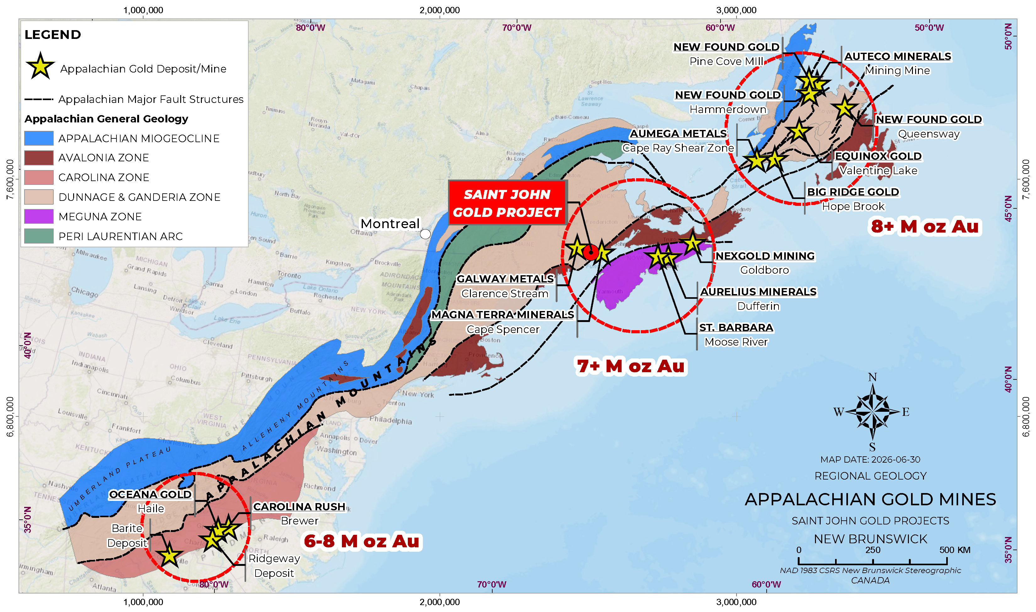
Galway Metals — structurally controlled gold along a major fault system.
New Found Gold — high-grade Appalachian gold discovery.
Agnico Eagle — analogous deep-fault-hosted goldfield.
Surface rock-chip, grab and trench sampling across the property's prospects has returned high-grade copper, gold, silver and antimony, supported by associated molybdenum and rhenium. Four prospects have been identified along the mineralized corridor: Little Lepreau, Shadow Lake, Prince of Wales (incl. Vinegar Hill) and Hideaway.
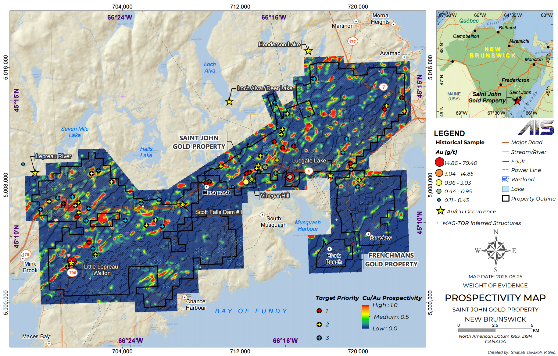
Surface samples up to 41.6 g/t Au, 1,600 g/t Ag and 7.64% Cu, with antimony up to ~10.8% Sb in the quarry area. Situated within an interpreted magnetic low.
One of the property's two priority targets alongside Little Lepreau. Trenching along a 100 m length returned copper grades of 2.1%–6.7% Cu, and a metre-wide exposure of the mineralized contact carried over 1% Cu together with 0.2% Mo (molybdenum) and 4 g/t Re (rhenium) — rhenium being a rare critical metal used in high-performance aerospace alloys. Some of the highest-grade copper here occurs as “grey copper,” a naturally copper- and antimony-rich mineral, which is why copper and antimony consistently appear together in the same high-grade samples (grab samples up to 17.6% Cu). A magnetite-rich intrusive and zones of massive hematite (specularite) support the interpreted iron-rich IOCG system.
Surface samples up to 10.55% Cu and 11.4 g/t Au, with silver to 1,050 g/t Ag. Quartz veining with chalcopyrite along the fault zone.
Surface samples up to 2.01% Cu and 1.70 g/t Au, with silver to 8.05 g/t Ag.
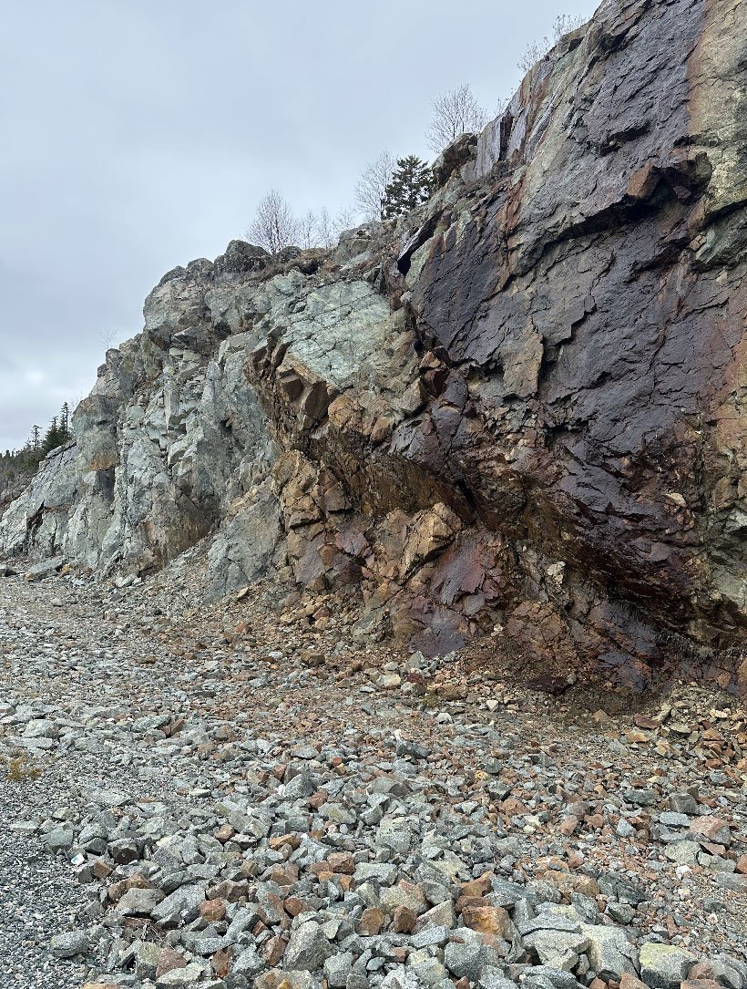
Outcrop and hand-sample photography from the Saint John property. Photos: Marc Enright-Morin.
Exploration at Saint John spans prior work carried out by the vendor, Riversgold Ltd. — whose surface sampling and geological results were disclosed on the ASX (January 29 and April 9, 2025) — and the Company's own program since it entered an earn-in agreement on the project on September 15, 2025.
High-resolution drone magnetic survey over Little Lepreau received and used to refine target definition.
Further high-grade sample results reported across the prospects.
A high-resolution drone magnetic survey was flown at 25 m line spacing over the Little Lepreau Prospect, delineating multiple magnetic-low response areas with signatures similar to the Little Lepreau Roadside Quarry mineralization. Petrophysical testing of a sulphide sample returned very high chargeability and low resistivity, supporting the use of drone MobileMT (MMT) surveying on the property.
High-resolution survey over Little Lepreau, compared against the 400 m regional dataset.
Helicopter-borne magnetic survey flown at 50 m line spacing.
Rock-chip / grab / trench assays across Little Lepreau, Shadow Lake, Prince of Wales and Hideaway.
Simplified structural & mineralized-trend interpretation.
In 2026, A.I.S. reported initial assays from 38 grab and chip rock samples submitted to Actlabs across the Company's New Brunswick projects, collected as part of its due diligence to confirm historical results and identify new prospects. Twenty-three samples exceeded the laboratories' upper detection limits for copper, gold, silver, lead and/or antimony and have been submitted for re-assay, with results to be released on receipt. The samples returned elevated values in copper, gold, silver, cobalt, nickel, molybdenum, lead and antimony (news release dated June 8, 2026).
A ~2,000 m maiden diamond drill program targeting high-grade zones at Little Lepreau is planned for summer 2026.
A.I.S.'s 2026 sampling returned multi-element mineralization across several target areas — including the Lepreau and Prince of Wales prospects — which the Company interprets as evidence of multiple styles of mineralization that warrant systematic follow-up. Results, combined with historical and current geophysical data, will be used to develop the upcoming drill program, for which a local driller has already been contracted (news release dated June 8, 2026).
Investor Updates
Receive the latest news releases and corporate updates from AIS Resources Ltd. directly to your inbox.
We respect your privacy. Unsubscribe at any time.